Garmin
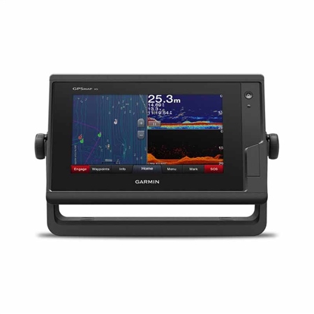
GPSMAP 722xs 7 inch ClearVu Chartplotter - Worldwide Basemap
7-inch Touchscreen Chartplotter/Sonar Combo: 7-inch high-resolution intuitive touchscreen controls. NMEA 2000Â and NMEA 0183 support for network connectivity, including autopilots, digital switching, weather, FUSION-Link, VHF, AIS and more.
Part number: NE450255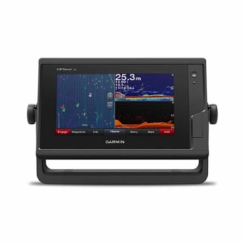
Garmin GPSMAP 722xs 7 inch ClearVu Chartplotter - Worldwide Basemap
- 7-inch high-resolution intuitive touchscreen controls.
- NMEA 2000 and NMEA 0183 support for network connectivity, including autopilots, digital switching, weather, FUSION-Link, VHF, AIS and more.
- Garmin Marine Network support for sharing sonar, including Panoptix sonar, maps, user data, radar and IP cameras among multiple units.
- Supports optional BlueChart g2 Vision HD charts for Auto Guidance and other premium navigation features.
Experience an advanced navigation solution with this compact 7-inch GPSMAP 722xs touchscreen combo. Includes wireless connectivity features for Garmin mobile apps, NMEA 2000 support and Garmin Marine Network capabilities for radar and Panoptix all-seeing sonar, including Panoptix FrontV collision avoidance sonar. It also has built-in Garmin CHIRP and CHIRP ClearV sonar (transducer sold separately).
Full-network compatibility allows you to add more capabilities to your boat. Garmin Marine Network support allows sharing of sonar, including Panoptix sonar, maps, user data, Garmin radar and IP cameras among multiple units. Plus, theres NMEA 2000 and NMEA 0183 support for connectivity, including autopilots, digital switching, weather, FUSION-Link, VHF, AIS and other sensors.
Enjoy built-in ANT wireless connectivity directly to quatix marine watch, Garmin Nautix in-view display, gWind Wireless 2 transducer, GNX Wind marine instrument and wireless remote controls.
Built-in Wi-Fi gives you access to the free all-in-one ActiveCaptain app, so you can manage your marine experience from nearly anywhere. It creates a simple yet powerful connection between your compatible mobile device and your Garmin chartplotter, charts, maps and the boating community. Wherever you are, youll have unlimited access to your cartography, the ability to purchase new maps and charts and access to the Garmin Quickdraw Contours Community. Stay connected with smart notifications on your chartplotter screen. You can also plan a trip or pre-fish a lake, and ActiveCaptain will automatically sync with your chartplotter. Even get notifications for software updates, and decide when to download them on your device.
Right out of the box, you have access to some amazing sonar capabilities; all you add are transducers. Comes with built-in Garmin 1 kW CHIRP sonar and CHIRP ClearV scanning sonar. It even supports Panoptix all-seeing sonar, premium Garmin sonar modules and a wide range of transducers (sold separately). Networked combos can share their internal sonar with any other device on the network. You can also choose what information is overlaid on the sonar screen, for example, radar, time of day or GPS speed. Fast, responsive built-in 10 Hz GPS and GLONASS receiver refreshes your position and heading 10 times each second to make your movement on the screen more fluid. It makes dropping up to 5,000 accurate waypoints and finding your way back to them quick and easy.
Includes expandable memory for accessory map purchases, such as LakeV HD Ultra with Max Def Lakes or BlueChart g2 Vision HD, which adds Garmin patented Auto Guidance and other great features. Instantly create personalized HD fishing maps onscreen with 1-foot contours. Tailor them to fit your needs. These are your maps you own them. Keep the data to yourself, or share it with the Quickdraw Community on Garmin Connect. To help you gain a wind-maximizing competitive edge, your chartplotter features a pre-race guidance page that shows your virtual starting line along with data fields showing lay lines, time to burn before the start and a race timer that can be synchronized across all your networked Garmin GPS products. In addition, other supported sailing features include an enhanced wind rose, heading and course-over-ground lines, set and drift, true and apparent wind data and more. If you have waypoints, tracks or frequently used routes stored on another manufacturers GPS product or on a Garmin handheld device its easy to transfer those items to your new Garmin chartplotter via industry-standard GPX software formatting.
Compare prices
About

|
GPSMAP 722xs 7 inch ClearVu Chartplotter - Worldwide Basemap
New · Out of stock |
£1,014.00 Incl. VAT |
Visit site |
|---|